General navigation for ATPL – Find the triangle
I told you there is a system in the madness.
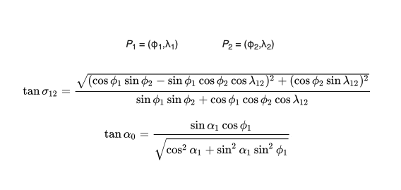
If you want to calculate track and/or distance for an EASA General navigation exam question without using the classic great circle formulas and after all the other shortcuts have failed then you must find the triangle in the lines that connect the two coordinates.
How computers do it
Before JAR-FCL took over the ATPL exams in Europe around the year 2000, you would remember the formulas for great circles, go to the exam, insert the coordinates of A and B into them and presto! Bob’s your uncle.


The EASA way, how the ATPL exam does it
Fast forward to today. The EASA syllabus does not want you to learn the formulas for track and distance of a random great circle but they still want you to calculate tracks and distances. This is an interesting dilemma. The question writers must now find a way to make it look like General Navigation.
There are however some shortcuts and they allow you to calculate tracks and distances by simplifying them along meridians and parallels. That is, if you are lucky that the coordinates are both actually on the same meridian or parallel. Like this:
Previously in this series
Geval 1: Dezelfde meridiaan?
Tracks and distances between two “random” points
Geval 2: Dezelfde anti-meridiaan?
Case 3: Same parallel?
If these 3 cases do not apply you can use a method that I call “Find the triangle”. Usually when you end up here we are dealing with two positions that are in the polar regions. 70N or 70S or beyond.
Where is the triangle?
To have a triangle you need 3 lines. The great circle track is just one of them. The other two are usually meridians. Like this:

What is in the triangle?
The meridians are obvious, they are the two legs of the triangle. The dotted line is a straight line that completes it. Could be a track between two points.
Inside a triangle all the angles count up to 180 degrees and you can do some basic calculations to find the length of each leg.
Does it look familiar yet? You may recognise this as a POLAR STEREOGRAPHIC PROJECTION.
Look at this question from the European question bank:
On a Polar Stereographic chart, the initial great circle course from A 70ºN 060ºW to B 70ºN 060ºE is approximately:
A: 330º (T)
B: 030º (T)
C: 150º (T)
D: 210º (T)
This is what it looks like in a drawing.
You may notice that I draw the great circle from A to B as a straight line. This is close enough and you will find the correct answer.
In reality a great circle it is not a straight line in a polar stereographic projection but in our case this is close enough. There is in fact a slight curve concave to the pole but that’s a long story that I’m not going to cover here.

- Initial track is the requested answer.
- Inside the triangle the angles all add up to 180.
- ⍺1 = the difference in longitude between A and B = 120º
- There is now still 180 – 120 = 60º remaining in the triangle
- Looks like Initial Track and ⍺2 are equal so that would mean that are each 30º
How to proof that? –>
Well, it “happens” to be the case that the two legs of the triangle from the north pole to A and from the north pole to B are of equal length. As a result, the angles that they enclose are equal.
There’s the proof we need. Initial track = 030º.
Other variants to use this theme
Distances from ground features or beacons
A few very nasty questions exist that have basically nothing to do with navigation other than the words distance and bearing or even aircraft in them. In these questions you fly a track and a few minutes later the bearing to a feature happens to be part of a triangle with a 90 degree angle and two equal legs. They then want to know for instance the distance to the feature which happens to be equal to the distance travelled. Please.
It’s been a while so hopefully these questions have been deleted from the databases by now. What can I say.
Draw the tracks, you will see the triangle.
Approximately is the give-away
The word “approximately” means there is probably a triangle or some rule of thumb involved. The answer that you get is an approximation of the actual value.
- Two points that are on different parallels and different meridians but only a few degrees N or S apart are likely to form a triangle somewhere. This is also possible on a Mercator-projection near the equator.
- If you draw a triangle and you find a 90 degree angle then the solution is close-by.
- Some of the biggest headaches of GNAV for ATPL: Gridded charts in polar regions are a well known source of questions that contain triangles. The difference in longitude between the two points is usually a good starting point for your calculations.

