It is possible to have the circuits and the noise abatement procedures for EHHV Hilverum Airport on your Android device for free. The catch is that these maps are not the official airport charts and as such not approved for navigation.
But they do help a lot to improve your situational awareness.
Hilversum can be tricky: This can help improve your situational awareness
We all know that EHHV can be tricky to navigate. Finding it is one thing, but approaching one of the three runways from the correct side is another.
And then there are these “avoid” areas everywhere. They do not make things easier and you shouldn’t discard them as a nuisance to pilots!
Call it old school but I plan my flight before I go to the airport and use a GPS to cross-reference my position. It is after all VFR – Visual Flight Rules. Eyes outside.
All you need is the current VFR chart and the local plates from the AIP.
Obviously there apps like Foreflight, EasyVFR and SkyDemon. These are great apps with amazing features. But I never bought them.
There is one thing that I do to make my life easier. I take the visual approach charts from some of the airports from the Dutch AIP, download them and then align them with WGS84 in an app.
This is what you need to get georeferenced approach plates on your Android tablet for free
- Step 1: Install the “Custom maps” Android app
- Step 2: Download the prepared maps
- Step 3: Import the maps into the app.
Step 1: Install the “Custom maps” Android app
Step 2: Download the prepared maps
The source-material
I used two well-known mapsets as base material:
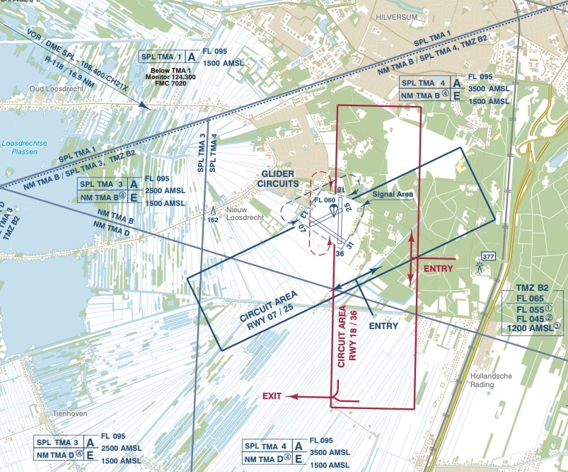
- The first is being distributed by the Airport Authorities and can be downloaded for free at the noise abatement page of EHHV.nl here.
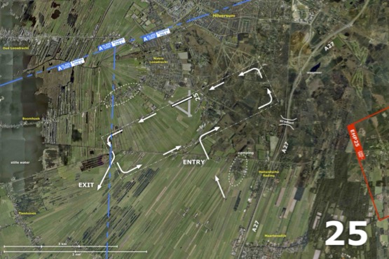
- The other is an overlay on Google Earth satellite images. Just to be clear, I did not draw the those maps and I do not have the copyrights. In fact I’m not sure anyone still knows who made them. If you do then please let me know. The PDF versions can be downloaded from the website of Vliegclub Hilversum here.
Hilversum Airport procedures
Aeroclub Hilversum-Amsterdam
The prepared files
You must agree with my disclaimer.
To make installation in step 3 easier do this download directly on your target device.
Use at your own risk and never as a stand-alone solution
Step 3: Import the maps into the app
To install a kmz file into the Custom maps app long-press the file in your document explorer and choose “Open with…”

Kaartjes zijn al een paar jaar geleden vernieuwd en komen niet van EHHV of de Vliegclub, maar Vliegschool Hilversum. Op verzoek kan ik ze toesturen.
Hey Frank!
Ik had het nog gevraagd op de vliegclub maar daar wisten ze het niet. Die nieuwe zou ik wil graag willen ja, interessant.